Description
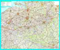
A highly detailed route-planning map from Kummerley and Frey. It covers Belgium and Luxembourg, going from Hertogenbosch in the north to Dillingen in the south, and Siegburg in the east to Hazebrouck in the west. There is a full index to place names on the reverse, and national and international boundaries are shown. Size: 105cm H x 125cm W, Format: Gold Framed
You may also like


loading
Discover more