Etsy - OldmapsShop Old World Map By Stanford, 1898 - Masterpiece Vintage Atlas Sepia Birthday Housewarming Gift Framed Or Unframed Large Wall Art
Price Tracked On This Product
Highest price was seen £59.00 on 02 May 2024
Lowest price was seen £47.20 on 25 Apr 2024
Average price is £48.72 base on 13 price changes
Most recent price is £59.00
Description
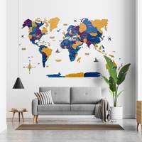
Handmade & dispatched locally! I print, frame & make old maps all around the world. I will make your map locally & deliver locally with your normal post or courier service. This means your map will usually arrive in 2-3 working days & ensures your map gets to you in perfect condition. (Plus, it reduces CO2 emissions by not flying old maps half way around the world!) Map personalisation This map can be personalised to make it truly unique. I will add a short message to the map that perfectly blends in. This is perfect for anniversaries, housewarmings, leaving gifts, & more. Please add this product to your basket before you checkout: https://www.etsy.com/uk/listing/1257156692/map-personalisation-add-on-item-please. Get in touch if you want to discuss an unusual or complex personalisation. have personalised thousands of maps over the years - I can almost certainly help you. Intro Established in 1984, the Unique Maps Co. sources the world's finest & rarest old maps from libraries & private collections around the world. I restore the maps in my workshop & then reproduce, customise & frame them to suit my customers' needs. I guarantee that you cannot find higher quality maps anywhere else. About this map This is an attractive, sepia, vintage toned world map from 1898 by Edward Stanford. By this point our cartography of the world was fairly accurate, & this is one of the earliest, full-size, accurate maps of the world. Established in 1984, The Unique Maps Co. sources rare original maps from around the world, & then lovingly restores them at a workshop in London. I guarantee that you cannot buy prints of these old maps, at this high quality, anywhere else. This map has many interesting & unique details, such as the paths of some of the earliest telegraph lines (undersea cables) between Europe & North America. There are also sea currents, trade winds, & primary ocean mail routes. Because of the huge amount of detail on this map, I would recommend buying the 36x20 inch (90x50cm) map at least. The map looks nice at 24x13 inches (60x33cm) but some of the labels & place names will be very small. Please note that there are white strips along the edge of the map if you buy the unframed map at smaller sizes (36x20 & 24x13 inches). They are very easy to snip off - or they may help you with framing. The other sizes, & all framed maps, are all exactly as per the listing images. I can print & frame this map at sizes up to 250cm wide - please get in touch if you'd like a larger size, or to discuss framing options & prices. This map, which uses the Mercator projection which was popular at the time, is in great condition & has been lovingly restored by me. This world map would make a perfect gift for someone who loves to travel or explore, or it would look great as wall art on your own walls! You can order the map itself, or you can order a framed version. The frame is a nice, simple black frame that really makes our maps pop out when on a wall. Please get in touch if
You may also like


loading
Discover more