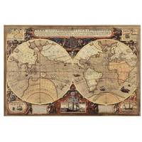
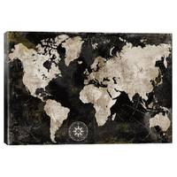
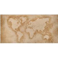
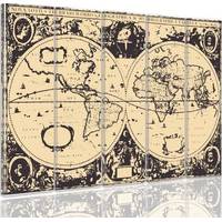
Etsy - OldmapsShop Old World Map, 1700 - Rare Monochrome Antique Atlas Chart
Price Tracked On This Product
Highest price was seen £38.00 on 02 May 2024
Lowest price was seen £27.20 on 04 May 2024
Average price is £27.97 base on 17 price changes
Most recent price is £28.90
Description
Handmade & dispatched locally! I print, frame & make old maps all around the world. I will make your map locally & deliver locally with your normal post or courier service. This means your map will usually arrive in 2-3 working days & ensures your map gets to you in perfect condition. (Plus, it reduces CO2 emissions by not flying old maps half way around the world!) Map personalisation This map can be personalised to make it truly unique. I will add a short message to the map that perfectly blends in. This is perfect for anniversaries, housewarmings, leaving gifts, & more. Please add this product to your basket before you checkout: https://www.etsy.com/uk/listing/1257156692/map-personalisation-add-on-item-please. Get in touch if you want to discuss an unusual or complex personalisation. have personalised thousands of maps over the years - I can almost certainly help you. Intro Established in 1984, the Unique Maps Co. sources the world's finest & rarest old maps from libraries & private collections around the world. I restore the maps in my workshop & then reproduce, customise & frame them to suit my customers' needs. I guarantee that you cannot find higher quality maps anywhere else. About this map This is probably the rarest antique atlas world map that has ever been published. Created around 1700 by Paolo Petrini in Naples, Italy, there are almost no copies of this map still in circulation. To buy the actual antique map would cost you more than 50,000. This variant is even rarer than the handcoloured version, which I have over here: https://www.etsy.com/uk/listing/876375867/old-world-atlas-map-1700-very-rare This map looks best at larger sizes, but looks great at all sizes, from 12x16 inches (30x40cm) to 16x20 inches (40x50cm), 18x24 inches (45x60cm) & 24x36 inches (60x90cm). If you have the space for it, go for one of the largest maps. I can print this map up to 48x60 inches (120x150cm). The model in the listing images is holding the 20x16 inch (50x40cm) version of this map. Back in the 1700s, our understanding of the world wasn't quite what it is today. California is an island! There's still no Antarctica (it won't be discovered until the 1800s), but the other continents are just about there: Europe, South America, Africa, Asia & North America. The western coast of Australia has been discovered - but the eastern side remains unknown. This is also one of the first atlas maps to have an outline of New Zealand. Taking a closer look at North America, you can see that things go a bit weird north of California, into where modern day Alaska would be. There's the mythical Strait of Anin, which was believed to mark the border between America & Asia. Very little is known about Paolo Petrini, other than he published a very rare & beautiful atlas called Atlante Partenopeo between 1700 & 1718, from which this world map is from. There may only be 1 copy of this map in existence, so you are buying a pretty special print here. Around the edge of the map
You may also like


loading
Discover more