Description
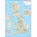
Brayden Studio The 'British Isles Routeplanning Map' Graphic Art Print shows the motorways, major roads and transport hubs such as airports and rail routes in the UK. Route planner maps show the major towns and their approximate population in the British Isles. Route planner map also contains the useful table of towns and their distance apart. Extremely useful in organising journeys - times and route planning. This 'British Isles Routeplanning Map' Graphic Art Print (laminated) with encapsulation gives the map a write on/wipe off finish. Please note that the edges of this print are not sealed.
You may also like


loading
Discover more